Back Alster Afrikaans ألستر Arabic نهر الستر ARZ Альстэр (прыток Эльбы) Byelorussian Alster BS Alster (Elba) Catalan Alster (suba) CEB Alstera Czech Alster Danish Alster German
You can help expand this article with text translated from the corresponding article in German. (June 2012) Click [show] for important translation instructions.
|
| Alster | |
|---|---|
 Aerial view of the Alster's two lakes in Hamburg | |
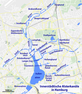
 Map of Alster and canals in Hamburg | |
| Location | |
| Country | Germany |
| States | |
| Physical characteristics | |
| Source | |
| • location | Henstedt-Ulzburg |
| • coordinates | 53°45′49.1″N 10°0′17.4″E / 53.763639°N 10.004833°E |
| • elevation | 31 m (102 ft) |
| Mouth | Elbe |
• location | Hamburg |
• coordinates | 53°32′40″N 9°59′0″E / 53.54444°N 9.98333°E |
• elevation | 4 m (13 ft) |
| Length | 56 km (35 mi) |
| Discharge | |
| • average | 5.8 m3/s (200 cu ft/s) |
| Basin features | |
| Tributaries | |
| • left | Bredenbek, Ammersbek, Saselbek, Osterbek, Wandse |
| • right | Tarpenbek, Isebek |
| Progression | Elbe→ North Sea |
The Alster (German pronunciation: [ˈalstɐ] ) is a right tributary of the Elbe river in Northern Germany. It has its source near Henstedt-Ulzburg, Schleswig-Holstein, flows somewhat southwards through much of the Free and Hanseatic City of Hamburg and joins the Elbe in central Hamburg.
The Alster is Hamburg's second most important river. While the Elbe river is a tidal navigation of international significance and prone to flooding, the Alster is a non-tidal, slow-flowing and in some places, seemingly untouched idyll of nature, in other places tamed and landscaped urban space. In the city center, the river forms two lakes, both prominent features in Hamburg's cityscape.
© MMXXIII Rich X Search. We shall prevail. All rights reserved. Rich X Search